
Patrol inspectors should carry on-line patrol device, patrol on the prescribed patrol line. Patrol inspectors automatically upload location information and time information to the management center through GPRS. Through electronic maps, managers can monitor the location of inspectors and their work on site in real time. Through system software, the returned data are analyzed, processed, trajectory playback, statistics and report forms are made. Provide a scientific and accurate assessment basis for managers.
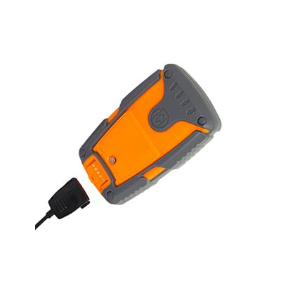
The patrol inspector is made of ABS engineering plastics. It has excellent physical and thermal properties. It is completely waterproof, fall-proof and shock-proof. IP65 protection level is achieved. It can still work freely falling from 30 meters high. Military-level design, really achieved a solid three-proof online patrol detector, using two-color integrated injection molding, the overall design is compact, all components and plates are fixed without screw, beautiful appearance, satellite positioning, RFID radio frequency identification combined with GPRS wireless transmission. A new type of waterproof and anti-destructive contact USB communication (mainly used to download initialization parameters when the first patrol is used), 2000 mAh battery capacity, powerful function.
& Sup2; large monitoring capacity, easy expansion and good compatibility of the system;
& Sup2; can real-time master the working status of patrol personnel and the patrol circuit;
& Sup2; can use electronic map to playback walking route, image, lifelike;
& sup2; accurate location information, timely data transmission;
& Sup2; GPRS data transmission mode, fast transmission speed and low cost;
& Sup2; Supporting the query of interactive location information with management center;
The management center can set the working parameters of the satellite positioning terminal according to the actual needs.
This system is a computer database management system for acquiring, storing, displaying and querying positioning data. It displays the information and data needed visually and intuitively on the electronic map in the form of graphs or tables, provides a good map environment for satellite positioning, and can also provide spatial information and attributes. Information processing is perfectly combined to display information such as position and state in an intuitive way.
Real-time satellite positioning patrol system sends satellite positioning data information to the monitoring and management center through GPRS network in time. The management center can monitor the working status of patrol personnel in time. In the electronic map of the management center, the route and location information of inspectors are tracked and displayed in real time. So as to achieve the purpose of effective management of the working status of inspectors and unexpected situations on the spot.