
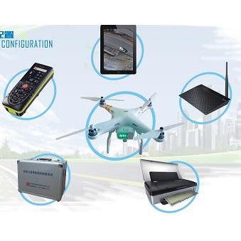
IPADTablet laptop
Operating system:iOS7.1Processor:A9 Chip Ownership64 Bit Architecture andM7 Motion coprocessor, storage capacity:32GBDisplay screen size:9.7Screen resolution:2048 x 1536Screen Description: Capacitive Touch Screen, Multi-point Touch Screen; Reference Device: Touch Screen;
Colour inkjet printerHP
Maximum print space:A4The number of cartridges: four-color cartridges; printing speed: black and white:22ppmColor:18ppmThe highest resolution:4800x1200dpiPaper feeding capacity:50Page; Print memory:64MBInterface type:USB2.0 PictBridgePort Bluetooth Port; Print Load:500Page; Power supply:40WProduct size:348*175*84mm。 Supported medium size:A4; A5; A6; B5 (ISO)Custom size76.7 x 216 reach 101 x 355.6 Millimeter;
Laser Range Finder Leica
Video Viewing, Wireless Bluetooth Function, Measurement Accuracy +/-1.0mm +/-0.3& Deg range of measurement ___________0.05m-200mThere is the largest./Minimum measurement function; plus/Reducing function; having area./Volume calculation function; indirect measurement.(Pythagorean Theorem)Function; function as a timer./Continuous measurement function; measurement range in tilt sensor+/-50& deg has trapezoidal measurement function; call the last20There are three measurements.4Double digital sighting function; tripod threads; backlight display/Multifunctional base; splashproof/dustproofIP54Function; each battery can be measured at least5,000Second;
Vehicle Charger
Input voltage range:11.5VDC~14.5VDC/ 22VDC~28VDCOutput voltage range:110VAC+5%/ 220VAC+5%Output frequency:50Hz~60HzInput waveform: corrected sine wave; power factor:0.8。
Special Toolbox
High strength aluminium alloy material, anti-seismic, waterproof, moisture-proof, sun protection.
Ranging Aid Board
Aluminum Reflector Used in Distance Finder。
Unmanned Aerial Vehicle Camera Equipment
Image Sensor1 inchCMOS Effective Pixel2000 ten thousand
Lens perspective:77 & deg; equivalent focal length:28 mm
Aperture:f/2.8 - f/11
Focus:1 m To infinity (with autofocus)
ISORange Video:100 – 6400
Photo:100 - 3200(Automation)100 - 12800(Manual)
Shutter speed electronic shutter:8 - 1/8000 s
Maximum Photo Size5472*3648
Traffic Accident Site Drawing Software System
The system meets the requirements of traffic accident handling standards and the working habits of the police, and strictly abides by the "Graphic Symbols of Road Traffic Accident Site".National Standard Development of GB/T 11797-2005, Road Traffic Accident Record Document (GA40-2008), Road Traffic Accident Site Mapping (GA49-2014), Traffic Accident Trace Evidence Investigation (GA41-2005);
★(2)The relevant software has the Software Copyright Registration Certificate, which is independently developed and developed, and the products have no copyright disputes.;
The system can draw the scale map of traffic accident scene quickly and accurately, draw the scene map by computer, automatically and quickly draw the sketch of road traffic accident scene, generate the scale map according to the requirement, and automatically generate the record of accident scene investigation.;
There are three independent drawing layers in the system, which can distinguish roads, icons and traces. The layers can be stored in layers by layers, so that no interference can be caused in drawing, and the wrong operation can be avoided effectively. Supporting triangular and right-angled positioning methods used separately or in combination, automatic and manual annotation can be used.;
(5)The drawing process conforms to the traditional drawing process habit of police officers. It does not need to fill in forms, and WYSIWYG is easy to find errors in real time. The operation adopts full left-click dragging operation mode, completes the same operation with the least number of keystrokes, shields right-click operation, and facilitates operation on tablet computer and field use.;
(6)It is easy to draw various forms of roads (such as straight roads, forks, etc.) with a handwritten pen.S-bends, intersections, T-junctions, various complex intersections, road profiles, unequal wide roads, irregular roads, etc.);
The parameters of the whole road can be set, and the parameters of each road can also be set (e.g. the width of lanes, the number of lanes, the width of individual lanes, etc.). The shape and style of various markings and green belts can be adjusted arbitrarily.;
Special roads can be generated (e.g. expressways, urban and rural roads, County roads, etc.).S-shaped road, etc.) S-shaped bend can be arbitrarily dragged by multiple control points, and can automatically mark various data.;
(9)It has the function of road memory, which can store the roads involved in the field maps and be easy to call directly in the future. It also has the function of road pre-storage, which can input the template of accident-prone sections and complex sections in advance, so as to make the field mapping more convenient and fast, or use it in combination with electronic map data.Less than data provided by users greater than
★(10) The system can realize cross-platform operation, and the generated drawing source files can be in Android.(AndroidApple(Ios, Microsoft (Windows), Microsoft(windows moblie)The four platforms run simultaneously on the equipment and share data across platforms.
★(11) Providing"Traffic accidentsthree-dimensionalsystem”InterfaceIt can automatically generate the three-dimensional dynamic effect of the accident scene.
★(12) It has the function of automatic direction recognition on site and realizes road orientation by means of magnetic azimuth angle. Finger North needle and scale should have adjustable function, default finger north and scaleThe ratio of 1:200.
★(13) DigitalPhotogrammetric function,Multiple sheetsPhoto correlation measurement, andPrinting《RoadScene Record of Traffic Accidents》
Software module of scene mapping system for traffic accident scene investigation
The system conforms to the new national standardGA49-2014 requires that it has the function of real scene drawing and can be transformed from real scene to scale map. Data can be automatically generated by ranging scale. In large-scale accident scene, multiple photographs can be taken, and the position of datum point and datum line can be marked in the real scene photographs, and the related photographs can be transformed into the scene map at the same time.
10.Software Module of Aerial Photogrammetry and Drawing System on Traffic Accident Site
1、Intelligent UAV and "Road Traffic Accident Site Mapping System" can be used together to facilitate the use of products.
* 2. It can be directly used in conjunction with the "Traffic Accident Scene Surveying and Mapping System". It can directly draw the scene record and scale map of the accident scene on the tablet computer without importing the photos into other equipment.
* 3. Design and develop an independent flight control interface, which is more suitable for road traffic accident scene investigation.
* 4. Automatically setting "return point" to display UAV status information and flight information in real time (such as signal, intensity, power, flight speed, distance, etc.).
* 5. The software automatically corrects, splices and generates measurement data for the incoming live photos.
* 6. The system provides four layers, which can separate road, symbol, trace and UAV scene layers to avoid misoperation.