Ten years of trees and a hundred years of tree people, Nanjing has been testing for ten years to sharpen a sword, the quality is rock-solid, your choice is professional, we pay for the quality! Long-term outstanding agents recommended for you:
Lightweight and waterproof GPS 72H, so that we can enjoy the water together! Professional, intimate, all-waterproof floating design, scientific and rigorous single-point positioning average function all shows its professional quality, using a spiral antenna with faster star search and higher sensitivity. With USB interface, and improvements in airline, memory and display area, the enhanced performance of GPS 72H has been greatly improved, becoming a new generation of Garmin's mainstream professional model in 2011.
Fast acquisition of satellite signals
Using GPS 72H highly sensitive GPS receiver, you can easily find your location and direction. GPS 72H can accurately measure the coordinates of your position under very complex conditions, such as in dense forests or deep canyons.
Use on land or water
There is no need to worry about GPS 72H falling into the water. Its waterproof grade is IPX7. It will float on the water surface whether on water or on land. GPS 72H can store up to 500 navigation points and guide your destination.
Storage of important data
GPS 72H is compatible with NMEA 0183. GPS 72H can also be connected to a computer via USB to transmit your stored data. If you want to go boating, hunting or fishing, you can also use 72H built-in astronomical data to help you complete, including sunrise/sunset time and hunting and fishing calendars.
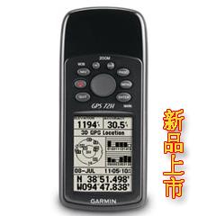
GPS 72H: High Sensitivity and Floating Design GPS
Advanced Enhanced Version of GPS 72 and Full Upgrade of Software and Hardware in 2011
The latest area measurement function, adding "mu" in the unit, has high measurement accuracy.
High sensitivity GPS chip can still locate accurately and quickly in dense forest and Canyon
Preset Beijing 54 and Xi'an 80 coordinates
Increased USB data interface, more convenient data transmission
Hardware and performance:
Size: 6.9*15.7*3.0 cm
Display screen size: 2.6 inches
Screen resolution: 120*160
Memory: None
Support Storage Card: No
Weight (including batteries): 218 grams
Battery Specification: 2 Sections 5 (AA) Batteries
Battery life: 18 hours
Waterproof index: IPX7
Floating: Yes
High Sensitive Receiver: Yes
Interface: USB + Serial Port
Data recording:
Number of airlines: 3000
Route (line): 50
Track Recording (Points): 9999
Keep track (bar):9
Map:
Pre-installed Detailed Map: No
Additional Maps: No
Navigation Map Support: No
Supporting contour maps: no
DEM Elevation Map Support: No
Supporting homemade picture maps: No
Functions:
Electronic Compass: None
Barometric Altimeter: None
Track measurement area:
Route survey area: Yes
Average position: Yes
Beijing 54 coordinates/Xi'an 80 coordinates:
Wireless Data Transfer: None
Buzzer Sound Reminder: Yes
Photographic function: none
Picture Browser: None
Photo Navigation: None
Sun and Moon Information: Yes
Support Custom Interest Points: No
Compatible Tidal Meter: No