Ten years of trees and a hundred years of tree people, Nanjing has been testing for ten years to sharpen a sword, the quality is rock-solid, your choice is professional, we pay for the quality! Long-term outstanding agents recommended for you:
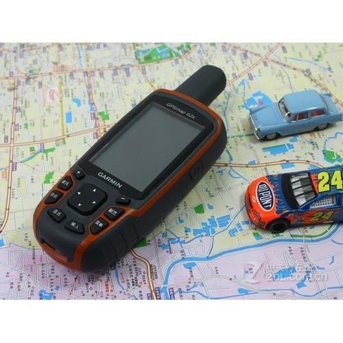
A novel GPS MAP 62s hand-held navigator is designed. It is equipped with a 3-axis tilt compensated electronic compass and barometric altimeter. Custom Maps, BirdsEye Satellite imagery and photo browsing functions are also supported. The robust and waterproof GPS MAP 62s uses a four-band helical antenna to achieve unparalleled reception performance. It is equipped with a high-speed USB connection, a new design with bright lines, and can be wirelessly connected to compatible Garmin handheld devices.
Exploring the World
GPS MAP 62s with built-in world map can easily navigate anywhere. With the photo browsing function, you can download and browse pictures from Garmin Connect Photos.
Lock your position
GPS MAP 62s has a built-in electronic compass with 3-axis tilt compensation, which shows your orientation even when you are still, without horizontal placement. Its barometric altimeter tracks pressure changes and points out your precise altitude. You can even use a GPS navigator or graphics of ambient pressure over time to help you focus on weather changes.
Wireless Sharing
Using GPS MAP 62s, you can share wireless data of your destinations, routes, tracks and treasure hunting information with other compatible equipment users. Now, your friends can also share your favorite hiking or treasure hunting activities - just press the "Send" button to send messages to similar devices and start the game.
Let you never lose your way
GPS MAP 62s is equipped with four-band helical antenna, high sensitivity, WAAS-supporting GPS receiver, and HotFix® satellite prediction function, even if you are in dense forest or construction area, GPS MAP 62s can quickly and accurately lock your position. Obvious advantages - whether you are in deep woods or close to tall buildings or trees, as long as you need, GPS MAP 62s will help you find the way forward.
Additional Map
It is easy to add maps by using various detailed charts, topographic maps and road maps provided by Garmin. With 1.7G on-board memory, you can easily download 24K and 100K topographic maps and start at once. BlueChart® G2 pre-installed card can be inserted when water activities are carried out; City Navigator NT® can be loaded on the road; map data can be used to select routes at various turning points (refer to map tab for compatible maps). GPS MAP 62s also supports BirdsEye Satellite Imagery (subscription required), which allows you to download satellite images and integrate them with your map. In addition, 62s is compatible with Custom Maps, a free software that converts paper maps and electronic maps into maps that can be downloaded from your device.
Free Connection
When you are busy exploring the environment and want to store and analyze your activities, you can analyze your activities in detail by connecting Garmin Connect () to your computer and Internet. Easily send routes to your outdoor equipment. Use the activity list provided by Google Earth one-stop website to help you see timely activity information on the map, and use the tens of millions of other routes uploaded by Garmin Connect users to share your experience on Twitter® and Facebook®. It's very convenient to use. Let's go out and explore and share.
Search for fun
GPS MAP 62s supports geocaching GPX files, which can download treasure data and details directly to your device. Paperless access not only helps improve the environment, but also improves efficiency. GPS MAP 62s stores and displays important information, including location, terrain, difficulty, hints and instructions, which means that no manual input is required and printed on paper! Just upload the GPX file to your device and start hunting for treasure. GPS MAP 68s is super thin and portable, which is the best companion for your outdoor activities.
GARMIN Handset 6 Series Most Full-featured Top Computer Emperor
Supporting Digital Elevation Model Diagram and Contour Diagram
Pre-install the latest City details to realize navigation and path planning functions
Supporting Wireless Data Sharing
With three-axis electronic compass, azimuth data is more accurate
Accurate height measurement with barometer
Hardware and performance:
Size: 6.1*16.0*3.6 cm
Display screen size: 2.6 inches
Screen resolution: 160*240
Memory: 4G
Support Storage Card: MicroSD Card
Weight (including batteries): 260.1 G
Battery Specification: 2 Sections 5 (AA) Batteries
Battery life: 20 hours
Waterproof index: IPX7
Floating: No
High Sensitive Receiver: Yes
Interface: USB (support NMEA0183)
Data recording:
Number of airlines: 2000
Route (section): 200
Track Recording (Points): 9999
Save track (bar): 200
Map:
Pre-installed Detailed Map: Yes
Additional Maps: Yes
Navigation Map Support: Yes
Supporting contour maps: Yes
DEM Elevation Map Support: Yes
Supporting homemade picture maps: Yes
Functions:
Electronic Compass: Three Axis
Barometric Altimeter: Yes.
Track measurement area:
Route survey area: Yes
Average position: Yes
Beijing 54 coordinates/Xi'an 80 coordinates:
Wireless Data Transfer: Yes
Buzzer Sound Reminder: Yes
Photographic function: none
Picture Browser: None
Photo Navigation: Yes
Sun and Moon Information: Yes
Support for custom interest points: Yes
Compatible Tidal Meter: Yes