Ten years of trees and a hundred years of tree people, Nanjing has been testing for ten years to sharpen a sword, the quality is rock-solid, your choice is professional, we pay for the quality! Long-term outstanding agents recommended for you:
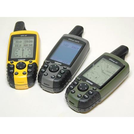
Map60CSx is the latest series of hand-held + vehicle dual-purpose data acquisition devices. It not only follows the advantages of vehicle-based products in intelligent route selection and navigation, but also has the lightness and dexterity of hand-held products. A new type of quadruple helix antenna is designed, which can add new landmarks to Chinese naming and has the function of measuring average position.
Map60CSx is the latest series of GARMIN handheld + vehicle dual-purpose data acquisition device. It not only follows the advantages of vehicle-based products in intelligent route selection and navigation, but also has the lightness and dexterity of hand-held products. A new type of quadruple helix antenna is designed. The Sirf III high sensitivity receiver chip is used internally. GPS signal capturing ability is much better than other built-in antenna models. New landmarks can be added in Chinese naming, and navigation point symbols can be drawn by software. It has the function of measuring average position. It can measure area easily by route and track. Including a variety of coordinate systems, a variety of spherical, flat display formats. Two sets of calculators of standard type and radian type are attached. With two connection modes of USB and RS232 standard serial port, the new low power design is more energy-saving. In addition, it is different from the previous hand-held devices in the use of microSD card memory card, can be arbitrarily replaced to expand storage space, convenient for you to store more tracks and maps.
Jisibao Map60CSx has
Higher accuracy: built-in quadruple helix antenna, more capable of receiving satellites;
Receiving star is more sensitive: Sirf III high sensitivity receiving chip is used;
Broad color screen: color screen design, large screen, easy to read information;
Map: Built-in the latest national road map, there are more than 2000 county-level city data detailed map;
Chinese Search: Intelligent search of navigation points, interest points, towns, intersections, addresses and other information;
Intelligent Route Selection: It can provide two navigation modes: along road and straight line, map zooming automatically, turning intersection zooming automatically, and providing a variety of navigation pages.
Electronic Compass: Built-in geomagnetic electronic compass, so that you will not lose your direction even in the case of GPS shielding;
Barometric Altimeter: Built-in barometric altimeter to improve the accuracy of elevation measurement;
Sound settings: Turn tips, information tips, etc. can be set to different sounds.
Self-built navigation points: new landmarks can be added to Chinese naming, and the navigation point symbols can be drawn by software.
Position averaging: It has the function of measuring the average position, so that the precise coordinates of a point can be measured more accurately.
Area measurement: It is easy to measure area by route and track. Route measurement area can be stored in 50, track measurement area can be stored in 20;
MicroSD memory card: MicroSD plug-in memory card can be used to expand storage space by changing cards at will. Tracks can be automatically saved to the memory card. The number of tracks can be saved only depending on the capacity of the memory card. You can also load more maps.
Coordinate transformation: including a variety of coordinate systems, various spherical and plane display formats; (commonly used in China, such as Beijing 54 coordinates or Xi'an 80 coordinates, as long as the input of local conversion parameters can be used);
Computing function: Two sets of calculators of standard type and radian type are attached, which make field operation more convenient.
Data transmission: USB and RS232 standard serial port are two connection modes, which can upload and download data such as point route and track conveniently and quickly (can output NMEA data).
Energy-saving design: The new low-power design is more energy-saving, two AA batteries work continuously;
Screen: Made of high-quality materials, the display screen is large, with bright background light. It can easily read information in strong sunlight or night.
Page: You can customize the page to make GPS closer to your work and life.
Language: bilingual display interface in Chinese and English;
Sound: Information prompt, alarm clock, etc. can be set to different sounds.
Tools: Including alarm clock, stopwatch, sunrise and sunset time, hunting and fishing and other life tools;
Entertainment: There are many kinds of games built-in, and new ways of playing will bring endless fun to your outdoor activities.
Outer shell: waterproof, anti-seismic, high temperature resistant, fully in line with the harsh working environment in the field;
Outside shape: The shape design conforms to ergonomics. It has a good hand grip and a reasonable button position. It is more suitable for one-handed operation by field workers.
Standard configuration:
GPS Receiver
USB Data Line
2G TF Card
Lanyard
Chinese instructions