Ten years of trees and a hundred years of tree people, Nanjing has been testing for ten years to sharpen a sword, the quality is rock-solid, your choice is professional, we pay for the quality! Long-term outstanding agents recommended for you:
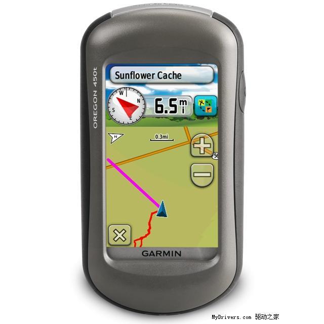
With Oregon 450, you can really get in touch with nature. This new generation of handheld devices is equipped with a rugged, easy-to-read touch screen in sunlight, support for halo topographic maps, high-sensitivity receivers, air pressure height, 3-axis electronic compass, microSD card slot, picture browser, etc. It can even exchange information of tracks, destinations, routes and treasures between similar devices by wireless means.
"Touch screen" operation, handwritten input makes the operation more convenient
65,000 color TFT touch color screen, super anti-glare screen display
Supporting Digital Elevation Model Diagram and Contour Diagram
Pre-install the latest urban detail map to realize navigation and path planning functions
Accurate height measurement with barometer
Supporting Wireless Data Sharing
Three-axis electronic compass, more accurate azimuth data
Hardware and performance:
Size: 5.8*11.4*3.5 cm
Display screen size: 3 inches
Screen resolution: 240*400
Memory: 4G
Support Storage Card: MicroSD Card
Weight (including batteries): 192.7g
Two AA batteries, two AA batteries
Battery life: 16 hours
Waterproof index: IPX7
Floating: No
High Sensitive Receiver: Yes
Interface: USB (support NMEA0183)
Data recording:
Number of airlines: 2000
Route (section): 200
Track Recording (Points): 9999
Save track (bar): 200*10000
Map:
Pre-installed Detailed Map: Yes
Additional Maps: Yes
Navigation Map Support: Yes
Supporting contour maps: Yes
DEM Elevation Map Support: Yes
Supporting homemade picture maps: Yes
Functions:
Electronic Compass: Three Axis
Barometric Altimeter: Yes.
Track measurement area:
Route survey area: Yes
Average position: Yes
Beijing 54 coordinates/Xi'an 80 coordinates:
Wireless Data Transfer: Yes
Buzzer Sound Reminder: Yes
Photographic function: none
Picture Browser: Yes
Photo Navigation: Yes
Sun and Moon Information: Yes
Support for custom interest points: Yes
Compatible Tidal Meter: Yes
Oregon 550 is more photographic than 450.